Cyclone

Cyclone Sitrang: Everything you need to know
Cyclone Sitrang formed over the east-central Bay of Bengal late on Sunday (October 23, 2022) evening. This is the first big storm that has developed in the Bay of Bengal in the month of October since 2018. Sitrang will track after Cyclone Asani, which formed in the Bay of Bengal in early May this year. It may cross the Bangladeshi coast by early Tuesday (October 25, 2022).
Which Bangladeshi districts are most vulnerable?
At least 19 Bangladeshi coastal districts are at the risk of being impacted. The Met office in Dhaka said in a bulletin on Monday morning that the cyclone may cross Barishal-Chattogram region by early Tuesday. Satkhira, Khulna, Bagerhat, Satkhira, Jhalakathi, Pirojpur, Barguna, Patuakhali, Bhola, Barishal, Laxmipur, Chandpur, Noakhali, Feni and three others offshore islands could be worst hit.
Read: Inland water transport suspended as Cyclone ‘Sitrang’ approaches
Will only Bangladesh be affected?
No. Forecasts predict that the cyclone will make its way over Bangladesh and the coast of neighbouring West Bengal on October 25 (Tuesday). The projection indicates that Sundarbans, on both sides of Bangladesh and India (West Bengal) could be the worst-hit. Kolkata, Howrah, and Hooghly in West Bengal would see a moderate amount of rain on Monday and Tuesday. Southern Assam, east Meghalaya, Nagaland, Mizoram, Manipur, and Tripura might get moderate to heavy rainfall, according to India Meteorological Department.
How did Sitrang get its name and what does it mean?
It’s a Thai name (pronounced as Si-trang). Some say it means ‘leaf’.
Read: Cyclone Sitrang: Heavy rains continue to batter Bangladesh amid flood warning across coastal region
How cyclones are named?
According to the World Meteorological Organisation, more than one cyclone may form in the same area at once. So keeping track of them all, tropical storms are all given names. These storms are given names that are simple and memorable to ensure a better communication during a crisis. Usually, regional conventions give tropical cyclones their names.
There are four regional Tropical Cyclone Warning Centres and six Regional Specialised Meteorological Centres across the globe. They offer warnings and name cyclones. Of the six, one is the India Meteorological Department. A cyclone with sustained surface winds of 62 kilometres per hour or more is given name when it originates in the northern Indian Ocean.
Read Cyclone Sitrang: Maritime ports asked to hoist local cautionary signal No 4

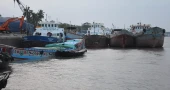
Inland water transport suspended as Cyclone ‘Sitrang’ approaches
Bangladesh Inland Water Transport Authority (BIWTA) has suspended the operations of vessels on all waterways across the country due to inclement weather caused by Cyclone ‘Sitrang’.
The suspension took effect at 10 am on Monday (October 24, 2022) and will remain in force till further notice, BIWTA public relations officer Mobarak Hossain told UNB.
Read:Cyclone Sitrang: Heavy rains continue to batter Bangladesh amid flood warning across coastal region
Besides, the leaves of all BIWTA officials have been canceled, he added.
The cyclone may cross the Barishal-Chattogram coast near Khepupara by Tuesday (October 25, 2022) early morning and because of the impact of the cyclone heavy rains would continue to lash the country, according to the latest bulletin of Bangladesh Metrological Department.
Read Cyclone Sitrang: Maritime ports asked to hoist local cautionary signal No 4

Cyclone Sitrang: Heavy rains continue to batter Bangladesh amid flood warning across coastal region
Authorities have prepared more than 1,000 cycone shelters to evacuate people while all fishing boats and trawlers over North Bay and deep sea have been asked to remain anchored until further notice as Cyclone Sitrang is expected to cross southern Bangladeshi coast by early Tuesday.
The Bay of Bengal will remain very rough near the eye of the cyclone, the weather office said on Monday morning.
According to the latest bulletin of Bangladesh Meteorological Department, Sitrang may make landfall near Khepupara along Barishal-Chittagong coast, and because of the impact of the cyclone heavy rains would continue to lash the country.
Read: ‘Sitrang’ may hit a 730 km area in Bangladesh on Oct 25: State Minister
Authorities in Chattogram and other hilly districts warned that landslides could destroy homes and kill people if incessant rains continue.
UNB correspondents from across southern coastal region reported heavy rains since morning.

Cyclone Asani recurves, likely to weaken into deep depression
Cyclonic storm Asani over West-Central Bay off Andhra coast recurved and moved northwards.
It is likely to move in a north or northeasterly direction and weaken gradually into a deep depression in the next 24 hours, according to a Met office bulletin.
Read: Cyclone Asani: Five coastal districts on alert
It was centered about 1,325 kms southwest of Chattogram port, 1,300 kms southwest of Cox’s Bazar port, 1,135 kms southwest of Mongla port and 1,170 kms southwest of Payra port around 12pm, the Met office said.
Maximum sustained wind speed within 54 kms of the cyclone centre is about 62 kmph rising to 88 kmph in gusts or squalls. Sea will remain very rough near the cyclone zone.
Read: Roofs ripped off houses as another cyclone hits Madagascar
Maritime ports of Chattogram, Cox’s Bazar, Mongla and Payra have been advised to hoist distant warning signal number 2 to warn ships living the ports of a depression at the sea.
All fishing boats and trawlers over the north Bay and in the deep sea have been advised to remain close to the coast and proceed with caution. They have also been advised not to venture into the deep sea.

Cyclone Asani unlikely to hit Bangladesh coast: State Minister
There is no possibility of Cyclone Asani, lying over the Bay of Bengal, hitting Bangladesh, State Minister for Disaster Management and Relief Dr Md Enamur Rahman on Sunday.
It may move towards Bangladesh after it makes landfall along the Indian coast on May 12, he said in response to a question from reporters at his office in the Secretariat.
Also read:Cyclonic storm ‘Asani’ moved northwestwards
He said the cyclone is moving northwestwards. It will weaken while passing through Odisha, Visakhapatnam, Bhubaneswar and West Bengal in India. “So far, no possibility of the cyclone hitting Bangladesh has been found.”
Due to the cyclone, there may be storms and rains in Bangladesh but there will be no cyclone or tidal wave, he added.
“This is the latest information we have.”
The state minister further said the cyclone currently lies in the Bay 1175 km from Chittagong port and 1250 km from Cox's Bazar. The speed of the cyclone is 55 kilometers per hour.
Asani, which formed in the Andaman Islands in the Indian Ocean on May 4, has gradually crossed the four levels of lows and turned into a cyclone at 6 am on Sunday, he informed.
Asked which part of Bangladesh may be hit if the direction of the cyclone changes, he said the direction of the cyclone changes all the time. It can take any turn at any time. “If the cyclone moves northwards, it may hit Satkhira, Khulna, Barishal and Patuakhali districts of our country.”
"We had a meeting last Thursday. There we have instructed our Ministry, Department, Fire Service, Meteorological Office, Cyclone Preparedness Program (CPP) and all,” he said.
Also read: Deep depression in Bay intensifies into cyclonic storm ‘Asani’
At the same time, the deputy commissioners of the coastal districts and the district disaster management committee have been warned about the cyclone.
"We have also instructed the cyclone shelters to be prepared," he said.
“We have paid for the rice and for cooking there. Cyclone shelters are instructed to maintain safe distances in compliance with health protocols,” the state minister said.

Bangladesh taking preparations to face possible cyclone: State Minister
The government is taking necessary preparations as cyclone 'Ashani' is likely to hit Bangladesh coast, said State Minister for Disaster Management and Relief Dr Md Enamur Rahman on Thursday.
Cyclone 'Ashani' may hit Satkhira district after hitting northeast India’s Odisha and West Bengal, the state minister told reporters after a meeting on cyclone preparedness at the Secretariat.
Also read: Cyclone Jawad: Over 1000 tourists stranded on St Martin's
He said that a cyclonic system has been developed near the Andaman Islands in the Indian Ocean which may turns into low pressure by Monday.
Then on May 11, it is likely to intensify into a deep depression and cyclone, he added.
“If it turns into a cyclone then the cyclone will be named Ashani,” he said.
However, its landfall has not been calculated yet. “After the formation of depression and cyclone, we can tell when it will hit the coast of Bangladesh,” he said.
The state minister said the country has bitter experiences and millions of people lost their lives in cyclones since Bangladesh is a cyclone- prone country.
“We are all alert now. We will take action according to the cyclone situation later,” he added.
Also read: Deep depression intensifies into Cyclone ‘Gulab’; Rain likely across country
Asked about necessary measures taken for the possible cyclone, he said cyclone shelters will be set up in case of deep depression. “We have about 7,000 cyclone shelters, if necessary we will use schools, colleges and other buildings.”
“We set up more than 14,000 cyclone shelters during cyclone 'Amphan'. We were able to shelter more than 24 lakh people there. We have that capacity and we are ready,” said the state minister.
.jpg)
Bay depression likely to intensify into cyclonic storm by midnight
The depression over north Andaman Sea and adjoining southeast Bay is likely to intensify further into a cyclonic storm by Monday midnight and move in a north/northeasterly direction.
It was centered at 06 pm today about 1120 kms south of Chattogram port, 930 kms south of Cox's Bazar port, 1115 kms south-southeast of Mongla port and 1040 kms south-southeast of Payra port.
Maximum sustained wind speed within 48 kms of the deep depression centre is about 50 kph rising to 60 kph in gusts or squalls.
Sea will remain rough near the deep depression centre.
Also read: Caution for maritime ports: Low pressure over Bay intensifies
Maritime ports of Chattogram, Cox's Bazar, Mongla and Payra have been advised to keep hoisted distant cautionary signal No one.
All fishing boats and trawlers over North Bay and deep sea have been advised to remain close to the coast and proceed with caution.
They are also advised not to venture into the deep sea.
Also read: Maritime ports asked to hoist local cautionary signal No 1

Roofs ripped off houses as another cyclone hits Madagascar
Cyclone Emnati crashed into the southeastern coast of Madagascar in the early hours of Wednesday, ripping roofs off houses and raising fears of flooding and food shortages in a region still recovering from the destruction inflicted by another tropical storm just weeks ago.
More than 30,000 people were moved to safe accommodation before Emnati arrived and Madagascar's National Office for Risk and Disaster Management estimates more than 250,000 people could be impacted by the latest cyclone.
There were no immediate reports of deaths or injuries from Emnati, but local authorities reported extensive damage to houses and other buildings in at least one southeastern city.
Read:Congo court sentences dozens to death over UN expert murders
Madagascar, an island off the east coast of Africa renowned for its wildlife and unspoiled natural treasures, has now been hit by four major tropical storms in the last month, killing nearly 200 people already and compounding issues of food insecurity. A drought in the south of the country left around 400,000 at risk of starvation last year, according to the U.N. World Food Program.
A string of aid agencies warned that Emnati will be a double blow for the eastern and southeastern regions that were hit by Cyclone Batsirai early this month. Batsirai ultimately left more than 120 people dead and displaced 143,000. More than 20,000 houses were destroyed or damaged by Batsirai, the U.N. Office for the Coordination of Humanitarian Affairs said, and more than 21,000 people remain displaced.
The U.N. humanitarian office said before Emnati arrived that it was in “a race against time” to protect people again.
Emnati made landfall around midnight local time in the district of Manakara Atsimo in the southeast, with average sustained winds of 135 kph (84 mph) and gusts as strong as 190 kph (118 mph), Madagascar’s Department of Meteorology said. Six regions in the southeast are on red alert, most of them already hard-hit by Batsirai.
“We can’t go out so it’s hard to see what happened but from what I can see from the gendarmerie barracks, there’s a lot of damage. Many houses no longer have roofs,” said Lt. Col. Harinaivo Randriamihajamanana, the commander of the Gendarmerie Group in the Fitovinany region and based in the city of Manakara. “We have not received any calls because the telephone communication has been very disrupted. We have had no electricity and water since yesterday (Tuesday) morning.”
The Emnati system had weakened as it worked its way over the Indian Ocean toward Madagascar, the meteorology department said, but it warned that flooding was still likely.
Manakara resident Gabriel Filiastre said his family joined others in taking refuge inside the main hall of a hotel where he works as Emnati hit.
Read:Soldiers declare military junta in control in Burkina Faso
“My house is completely flooded," Filiastre said. "We couldn’t sleep inside. It’s a wooden house. I saw a lot of houses around our house that are destroyed. For us, this cyclone did more damage than the one before.”
“Even in the hotel there is a lot of damage. One of the walls collapsed ... the roof tiles have been blown away and some of the ceilings of the rooms have collapsed. We need help."
The U.N. World Food Program and other aid organizations have warned of the risk of critical food shortages due to crops being destroyed and transport links disrupted. Forecasters have also predicted eight to 12 more cyclones in the Madagascar region before the cyclone season normally ends in May.
Emnati is expected to cross the southeastern part of Madagascar and spin out to sea again, according to the meteorology department, meaning it should miss mainland Africa, where previous cyclones have also caused deaths and destruction.

Maritime ports asked to hoist local cautionary signal No 3
The maritime ports of the country have been advised to hoist local cautionary signal number three as the deep depression over west-central bay and adjoining northwest bay moved north-northeastwards and lies over northwest bay and adjoining west-central bay.
It was centred at 06 am on Sunday about 875 kms southwest of Chattogram port, 855 kms southwest of Cox's Bazar port, 695 kms south-southwest of Mongla port and 725 kms south-southwest of Payra port.
It is likely to move further in a north-northeasterly direction and weaken gradually.
READ: Cyclone Jawad: Over 100 tourists stranded on St Martin's
Maximum sustained wind speed within 48 kms of the deep depression centre is about 50 kph rising to 60 kph in gusts or squalls. Sea will remain rough near the centre of the deep depression.
Under the influence of the peripheral effect of the deep depression, deep convection is continuing over north Bay and adjoining coastal areas of Bangladesh.
Steep pressure gradient persists over north bay.
Rain or thundershowers with temporary gusty or squally wind speed of 40-50 kph is likely over north Bay and adjoining coastal areas of Bangladesh.
READ: Cyclone ‘Jawad’ brewing in Bay of Bengal
All fishing boats and trawlers over north Bay and deep sea have been advised to take shelter and remain in shelter till further notice.
.jpg)
Cyclone Jawad: Over 1000 tourists stranded on St Martin's
More than 1000 tourists remain stranded on St Martin's island due to the hostile weather caused by Cyclone Jawad in the Bay of Bengal. The authorities have suspended the movement of passenger vessels between Teknaf and St Martin's Island for two days beginning from Sunday. Pervez Chowdhury, Teknaf Upazila Nirbahi Officer (UNO) confirmed the matter. Due to the bad weather, the local administration suspended the movement of all types of vessels by hoisting cautionary signal 3.
READ: Cyclonic storm ‘Jawad’ weakens into deep depression
The suspension will continue till the weather improves, the UNO said. St Martin's union parishad chairman Nur Ahmed, said the tourists got stranded due to the suspension of the trawler movement. “They have to wait until further notice”. All fishing boats and trawlers in the northern Bay of Bengal and deep sea have been advised to remain close to the coast and proceed with caution. And of course, venturing into the deep sea is strongly advised against.
READ: Tourist ships return to St Martin's island