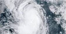
The former Hurricane Gabrielle was forecast to lash the Azores with hurricane conditions, including heavy rain, storm surge and large destructive waves starting Thursday, even after being downgraded to a post-tropical cyclone, according to the US National Hurricane Center (NHC).
Gabrielle, located about 120 miles (193 kilometers) southwest of the Azores, had maximum sustained winds of 70 mph (110 kph) and was moving east-northeast at 30 mph (48 kph). Swells were already reaching the islands, producing life-threatening surf, rip currents and coastal flooding. Forecasters warned of hurricane-force wind gusts across parts of the archipelago through Friday, with Portugal expected to see impacts over the weekend.
Up to 5 inches (13 cm) of rain could fall on the central Azores, triggering flash floods in mountainous areas, while the eastern and western islands could receive up to 3 inches (8 cm).
Meanwhile, Tropical Storm Humberto, located 470 miles (760 kilometers) east-northeast of the northern Leeward Islands, strengthened with maximum sustained winds of 60 mph (95 kph). Forecasters expect it to become a hurricane by Friday and possibly a major hurricane over the weekend, though its center is projected to stay offshore the United States.
Ragasa kills at least 18 in Taiwan and Philippines
Another tropical disturbance near the Bahamas, linked to flooding deaths in Puerto Rico earlier this week, could develop into a tropical depression in coming days, with increasing chances of affecting the US Southeast coast. FEMA urged residents to stay alert and prepare.
In the Pacific, Hurricane Narda was moving westward away from Mexico with sustained winds near 90 mph (150 kph). It could regain Category 2 strength by Friday. Swells from Narda are expected to reach Baja California Sur and southern California over the weekend, forecasters said.
Source: Agency