
With America’s aging road network falling further behind on long-delayed repairs, cities and states are increasingly deploying artificial intelligence to identify the most urgent hazards and prioritize maintenance.
In Hawaii, officials are distributing 1,000 AI-enabled dashboard cameras as part of an effort to curb a recent surge in traffic deaths. The dashcams automatically scan guardrails, road signs and pavement markings, distinguishing minor issues from serious problems that require immediate repair.
“This isn’t a once-a-month review where someone decides where to send their crews,” said Richard Browning, chief commercial officer at Nextbase, the company that built the cameras and imaging system.
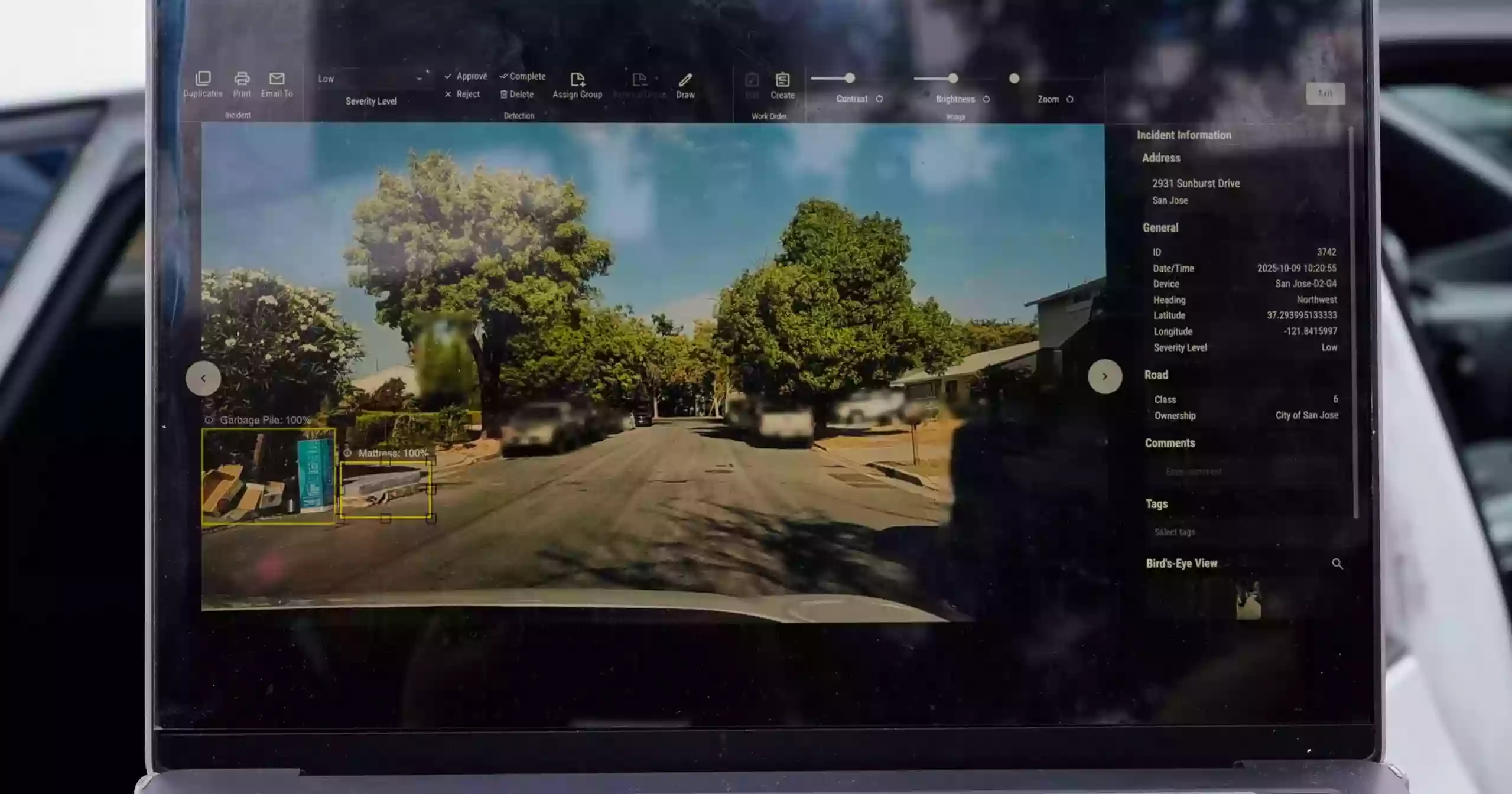
Other states are testing similar ideas. San Jose, California, began placing cameras on street sweepers, and city staff found the system identified potholes correctly 97% of the time. The city is now expanding the program to include parking enforcement vehicles.
In Texas — which has more lane miles than the next two largest states combined — officials are rolling out an expansive AI-driven safety program that uses cameras and voluntary cellphone data from participating drivers. Elsewhere, state agencies are using AI to monitor street signs and compile annual congestion reports.
Monitoring every guardrail, every day
Hawaii residents can sign up in the coming weeks for a free dashcam worth $499 under the “Eyes on the Road” campaign. The initiative was tested on government vehicles in 2021 but paused during the wildfire crisis.
Roger Chen, an engineering professor at the University of Hawaii helping oversee the project, said the state’s geography and supply-chain challenges complicate road maintenance.
“Equipment has to be shipped in. There are space and topographical constraints. It’s not straightforward,” Chen said.
While the system can detect debris and faded lane paint, its ability to flag damaged guardrails is especially emphasized.
Anthropic, Microsoft unveil massive AI data center projects amid industry expansion
“They are examining every guardrail in the state, every day,” said Mark Pittman, CEO of Blyncsy, the tech firm that aggregates dashcam feeds with mapping tools.
Guardrail maintenance is a sensitive issue in Hawaii. In 2024, the state paid $3.9 million to settle a lawsuit after a driver died in 2020 by hitting a guardrail that had been damaged for 18 months but never repaired.
Hawaii recorded its 106th traffic fatality of 2025 in October — already surpassing the previous year’s total. It is unclear how many were linked to roadway defects, but Chen said the rising toll highlights why the program is timely.
Building a national AI road database
San Jose officials say early results from road-scanning cameras have been promising. Mayor Matt Mahan, a Democrat and former tech entrepreneur, said the technology will become far more effective once cities pool their roadway images into a shared AI database.
The software can identify hazards it has encountered elsewhere, Mahan noted.
“It says, ‘That’s a cardboard box wedged between parked cars — that’s debris,’” he said. “We don’t have to wait years for that example locally.”
San Jose helped launch the GovAI Coalition in March 2024 to allow governments to share best practices — and eventually their data. Members include cities in California, Minnesota, Oregon, Texas and Washington, as well as the state of Colorado.
Simple fixes also matter
Some states are improving safety without relying on cameras. Massachusetts-based Cambridge Mobile Telematics developed StreetVision, which uses phone data to detect risky driving patterns. The tool helps state agencies identify road conditions that cause sudden braking or unsafe maneuvers.
At a recent Washington, D.C. conference, company executive Ryan McMahon recalled seeing a spike in aggressive braking on a nearby road. The cause: a bush had grown over a stop sign, blocking it from view.
“That pointed to an infrastructure problem — and the fix was just a pair of garden shears,” he said.
Texas has been relying on StreetVision and other AI tools to upgrade its massive road network. The technology recently helped locate thousands of outdated or missing road signs across 250,000 lane miles.
“If something was installed 10 or 15 years ago on paper, good luck digging it out of the records now,” said Jim Markham, a crash-data specialist at the Texas Department of Transportation. “AI lets us cover more ground, faster, than we ever could manually.”
Preparing for autonomous vehicles
Researchers say today’s AI tools lay the groundwork for an era when driverless cars become more widespread.
Pittman of Blyncsy predicts that within eight years, nearly every new vehicle — autonomous or not — will carry road-facing cameras.
“We need to understand the roadway from grandma in a Buick to Elon in a Tesla,” he said. “Transportation agencies are now designing infrastructure for humans and automated drivers, and they need to start closing that gap.”
Source: AP