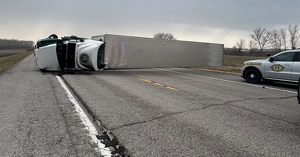
A massive storm system sweeping across the U.S. on Friday led to deadly crashes, overturned trucks, and widespread wildfires across multiple central states, triggering evacuation orders in several areas. At least five tornadoes struck Missouri, with forecasters warning of more severe weather in the Mississippi Valley overnight and in the Deep South on Saturday.
The National Weather Service cautioned that extreme weather could impact more than 100 million people. Winds reaching up to 80 mph (130 kph) were forecast from the Canadian border down to Texas.
In the Texas Panhandle, a dust storm led to car crashes that claimed three lives, according to Sgt. Cindy Barkley of the state’s public safety department. "It’s been a nightmare out here," Barkley said, noting that poor visibility made assessing the accidents difficult.
Oklahoma reported nearly 150 fires, according to Andy James of Oklahoma Forestry Services. Strong, dusty winds also overturned several tractor-trailers, the State Patrol said on X.
Charles Daniel, a truck driver navigating Interstate 40 in western Oklahoma, described the hazardous conditions. “The wind is whipping up dust, and I’m driving cautiously at 55 mph. Any faster, and I fear my truck will tip over,” he said.
Forecasters predicted the storm would continue wreaking havoc over the weekend, with a heightened risk of tornadoes and destructive winds in Mississippi and Alabama on Saturday. Heavy rainfall could also trigger flash flooding along the East Coast by Sunday.
Severe Tornado Threat Looms
The National Weather Service confirmed five tornadoes on Friday evening, including a damaging one near Bakersfield, Missouri.
“This is a life-threatening situation. Seek shelter now!” the agency warned on X.
The Storm Prediction Center forecasted that fast-moving storms could generate tornadoes, large hail, and straight-line winds reaching hurricane strength, with gusts up to 100 mph (160 kph).
A tornado watch remained in effect until 11 p.m. across parts of Missouri, Illinois, and Arkansas, while regions in Iowa, Kentucky, Tennessee, and Mississippi were also at risk.
Approximately 47 million people, from Madison, Wisconsin, to Birmingham, Alabama, faced an increased chance of severe weather. Forecasters expressed growing concern that intense thunderstorms further south could produce an even greater tornado outbreak on Saturday.
“We are highly confident that a tornado outbreak is likely tomorrow,” said meteorologist Evan Bentley of the Storm Prediction Center. High-risk areas include Jackson and Hattiesburg in Mississippi, as well as Birmingham and Tuscaloosa in Alabama. Severe weather is also expected in eastern Louisiana, western Georgia, central Tennessee, and the western Florida Panhandle.
Wildfires Fueled by Dry, Windy Conditions
The Southern Plains faced a high wildfire risk due to strong winds, warm temperatures, and dry conditions. Authorities issued evacuation orders in parts of Texas, Oklahoma, Kansas, Missouri, and New Mexico.
In Roberts County, Texas, northeast of Amarillo, a fire rapidly expanded from under a square mile (2 square kilometers) to 17.1 square miles (44 square kilometers) before crews contained it. Another fire 60 miles (90 kilometers) to the south spread to nearly 3.9 square miles (10 square kilometers) before firefighters halted its progression.
The Oklahoma Department of Emergency Management activated its emergency response center as fast-moving fires forced evacuations in Leedey and an area east of Norman.
Despite prepositioned firefighting teams, efforts to combat the flames were hampered by poor visibility from smoke and dust. Firefighting aircraft were deployed in some regions but were largely grounded due to hazardous conditions.
By evening, a “complex of extremely dangerous fires” was burning northeast of Oklahoma City near Stillwater, prompting evacuation orders for some residents, hotels, and even a Walmart.
Jennifer Thompson, a meteorologist with the National Weather Service in Norman, called the fire conditions in central and northern Oklahoma "historic and highly unusual."
Meanwhile, high winds caused road closures, including a 120-mile (190-kilometer) stretch of Interstate 70 in western Kansas. A major dust storm in Amarillo County, Texas, led to a 38-car pileup.
“This is the worst I’ve ever seen,” Barkley said. “We didn’t even realize how many vehicles were involved until the dust settled.”
Officials in Camden County, Missouri, urged some residents to evacuate as fires neared homes and businesses. Power outages affected more than 220,000 customers across Texas, Oklahoma, Kansas, and Missouri, according to poweroutage.us.
Blizzard Warnings for the Northern Plains
As the storm system moved north, the National Weather Service issued blizzard warnings for parts of western Minnesota and eastern South Dakota starting early Saturday. Snowfall of 3 to 6 inches (7.6 to 15.2 centimeters) was expected, with some areas possibly receiving up to a foot (30 centimeters).
Winds gusting up to 60 mph were forecast to create whiteout conditions, making travel dangerous. A thin layer of ice could also form before temperatures drop, further worsening road conditions.
