Water Development Board

Slow dam construction leaves Sunamganj’s Haor farmers on edge
Anxious days are returning for farmers in the haor areas of Sunamganj as work on crop protection dams remains sluggish, even three weeks after the official deadline for starting construction passed.
Although construction has begun in some haors, the overall pace has been slow, fuelling frustration among farmers who depend on the timely completion of embankments to protect their Boro crops from early floods.
Many fear that continued delays could leave vast tracts of farmland vulnerable during the coming monsoon.
According to the Water Development Board, several factors have hindered timely implementation.
Delays in the recession of water from the haors and complications in forming Project Implementation Committee (PIC) have stalled work in multiple upazilas, including Tahirpur, Derai and Shalla.
Fertiliser crunch threatens Kushtia’s onion boom despite high prices
Officials also pointed out that administrative activities were disrupted earlier as officials remained busy with election-related duties.
Despite these setbacks, officials said construction would gain momentum within a few days and that all projects are scheduled for completion by February 28.
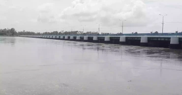
Mamun Hawlader, Executive Engineer of the Sunamganj Water Development Board, said that under the KABITA (Kajer Binimoye Taka) policy, a total of 705 projects have been approved for the construction of crop protection dams across 12 upazilas in the 2025–2026 fiscal year.
An allocation of Tk 137 crore has been made to build approximately 500.5 kilometres of embankments.
Although the construction work was formally inaugurated on December 15, progress has been limited.
As of January 6, work had started on only about 400 projects, with overall progress standing at just 15 per cent.
Bumper harvest, plunging prices; Chandpur’s potato market in crisis
Officials said the remaining projects would begin within a week.
A visit to several haor areas revealed that work has yet to begin on most approved projects, while some Project Implementation Committees are still waiting for official work orders.
The slow pace has drawn criticism from the Haor Bachao Andolan.
Leaders of the organisation recently held a press conference expressing concern that, despite the official start date, construction has not commenced in most upazilas.
They also alleged irregularities in the formation of PICs, unnecessary projects and additional allocations, raising doubts over whether the work can be completed within the stipulated timeframe.
Bijon Sen Roy, general secretary of the central committee of the Haor Bachao Andolon, said, “We are very worried about the dam work this time. The progress is very disappointing. If action is not taken now, it could spell bad news for the people of the haor.”
In response, Executive Engineer Mamun Hawlader assured that monitoring has been intensified and that dam construction will be completed on schedule.
According to the Department of Bangladesh Haor and Wetlands Development, Bangladesh has a total of 373 haors as of 2026.
These haors are spread across seven districts in the north-eastern and north-central regions, covering approximately 858,460 hectares.
As haor waters recede, Sunnamganj farmers sow hope in every field
Of them, 95 haors are located in Sunamganj district alone, spanning about 268,531 hectares.
As the agricultural season advances, farmers across Sunamganj continue to watch the embankment work closely, hoping that construction will accelerate before rising waters put their livelihoods at risk.
6 months ago

Unchecked soil lifting threatens Gomti River, infrastructures in Cumilla
Along the quiet banks of the Gomti River in Cumilla, an environmental crisis is unfolding in plain sight. As the winter dry season settles in, the river’s embankments, which shield nearby homes, farms and infrastructure, are being carved away by a surge of illegal soil extraction.
Local residents say the scale is unprecedented as soil is being removed almost continuously along both banks of the river, often in the presence of authorities and transported to brick kilns and construction sites across the district.
From Palpara to Golabari in Adarsha Sadar upazila, tractors move in and out of the riverbanks throughout the day. Villagers describe it as an ‘open season’ for soil lifters.
Read more: Six jailed for illegal soil extraction from govt land in Feni
A five-kilometre stretch on the northern bank and nearly 25 kilometres along the southern side have turned into extraction zones, locals say. The result is visible erosion -- sections of the embankment are collapsing, and parts of an adjacent paved road have already begun to break apart.
During a recent visit, at least 20 tractors were seen operating along the southern bank — in areas stretching from Durgapur to Samar Char. So relentless is the activity that operators have cut into the embankment itself to create makeshift access routes.
The northern side is no different. Soil is being dug out near electric poles, beneath tree roots and even in front of a police outpost at Chhatrokhil. Extraction continues near Chanpur Bailey Bridge and the western edges of Kaptanbazar.
Read more: Two jailed for illegal soil extraction in Chandpur
Residents say at least seven temporary ghats have been set up to load and transport the excavated soil across the river. They accuse local administrations of ‘silent permission’, allowing the practice to carry on despite widespread environmental damage.
7 months ago

Teesta cries for survival as northern Bangladesh’s lifeline runs dry
Once a mighty river that breathed life into northern Bangladesh, the Teesta now lies silent and broken, as its shimmering waters replaced by stretches of sand and its flow reduced to a faint memory for the millions who once depended on it.
The lifeline of two crore people lies gasping for breath as its waters vanishing, its banks eroding and its people left clinging to the memories of a river that once defined their existence.
Once a symbol of abundance, locals said, the Teesta today survives only in fragments, swelling briefly during monsoon, then receding into a barren desert of cracked sandbanks as winter approaches. The river’s decline has plunged the lives of Teesta basin residents into uncertainty, threatening their farms, fisheries and future.
By late October, the mighty Teesta had already dried up, long before the arrival of the dry season.
According to the Water Development Board (WDB), water flow at the Teesta Barrage point over the past 10 days averaged only 17,000 cusecs and continues to drop daily.
As the water disappears, so too does the livelihood of thousands. Farmers and fishermen along the Teesta’s banks say they are ‘dying along with the river’, WDB officials said.
Experts trace the beginning of this decline to the construction of India’s barrages at Gajoldoba near the Teesta’s entry point and at Doani in Lalmonirhat, which disrupted the river’s natural flow. Over time, its life-giving waters have been diverted through canals, leaving vast stretches of the riverbed dry.
Standing along the Teesta today, one can almost hear what locals describe as the ‘sigh of a dying river’, echoing across endless sand where strong currents once flowed.
Youth in Lalmonirhat stage flash mob demanding ‘Teesta Mega Project’
The river’s navigability has dropped so drastically that irrigation under the Teesta Barrage — the country’s largest irrigation project — may face severe challenges in the coming dry season. Large parts of the riverbed now lie exposed, marked only by shallow pools and scattered dunes, according to the officials.
Originating from Himalayan glaciers, the Teesta flows through India’s Sikkim, Darjeeling and Jalpaiguri before entering Bangladesh through Dahagram in Lalmonirhat. From there, it meanders through Nilphamari, Rangpur and Gaibandha before merging with the Brahmaputra. Once, its fertile chars produced rice, jute, maize, sesame and vegetables in abundance, shaping the region’s agriculture, culture and livelihoods.
However, the construction of the Gajoldoba Barrage in 1983 disrupted Teesta’s natural course — triggering water shortages in dry months and devastating floods in monsoon.
According to WDB data, more than 20,000 families have been displaced by river erosion in the past decade, with nearly 35 kilometres of riverbank severely eroded. Recently, a 350-metre stretch of the Teesta bridge protection embankment at Mahipur in Lalmonirhat caved into the river.
In Kurigram’s Ulipur upazila, over 100 homes have been lost to erosion, while in Gangachara more than 50 families have been displaced. Hundreds more remain marooned in four villages of Rajarhat upazila.
For years, residents of northern Bangladesh have taken to the streets under the slogan ‘Save Teesta, Save North Bengal’.
Environmental activists and locals have recently organised human chains, sit-ins and torch processions across Rangpur division, demanding immediate action.
Movement intensifies as Teesta activists announce ‘Silent Rangpur’ campaign in 5 districts
8 months ago

Waterlogged and forgotten: Over 5 lakh trapped in Jashore’s Bhabodah
What was once a mosaic of fertile fields and vibrant villages in Bhabodah of Jashore district has now been swallowed by weeks of floodwater, showing no sign of receding!
More than five lakh people in over 150 villages across Jashore and Khulna districts are trapped in a worsening humanitarian crisis, their homes, schools, farmland and livelihoods devastated.
The deluge, triggered by torrential July rainfall, has been compounded by years of river siltation, poor drainage and what locals describe as ‘decades of mismanagement’.
The worst-hit areas are Abhaynagar, Manirampur, and Keshabpur in Jashore and Dumuria and Phultala in Khulna.
On August 7, the Bhabodah Water Management Songram Committee submitted a six-point demand to the Jashore Deputy Commissioner, holding the Water Development Board (WDB) directly responsible for it.
Among their demands are the opening of all sluice gate vents, acquisition of land for the Amdanga canal, and fast-tracking the 81-kilometre river dredging project.
At present, only eight of the 21 vents in the Bhabodah sluice gate are operational, far from sufficient to drain the floodwaters. The committee alleges that poor decisions by the WDB have severely hindered natural water outflow.
Though an estimated Tk 1,250 crore was spent on Bhabodah-related projects over the past decade, locals claim no sustainable solution has been achieved. Allegations of corruption in project implementation are rife, with much of the funding reportedly misappropriated.
A Chinese expert team recently visited the Bhabodah sluice gate and offered long-term solutions, yet public trust remains low. Repeated unfulfilled promises and a lack of transparency have eroded confidence among flood-affected residents.
Severe waterlogging forces closure of two schools in Kushtia
Experts continue to advocate for the TRM (Tidal River Management) method, which utilises natural tidal flows to remove silt and restore river navigability.
A pilot TRM project in Beel Khukshia was previously successful and is now seen as a potential long-term remedy for Bhabodah.
The local committee has urged immediate implementation of TRM as part of their demands.
Nearly five lakh residents face an uncertain future, their only hope lying in urgent government action—grounded not merely in funding and promises but in transparent and accountable delivery of sustainable solutions.
Experts also point to unplanned human interference in natural waterways as a major cause of the crisis. Tidal flows, once instrumental in keeping local rivers navigable, have been disrupted by the construction of coastal polders in the 1960s and poorly planned sluice gates and embankments.
Excessive silt buildup now causes floodwaters to spill into residential areas during monsoons.
A visit to several villages in Manirampur upazila, including Kultia, Lakhidanga, Baje Kultia, Aminpur and Hasadanga, revealed the dire conditions.
Laxmi Rani Biswas of Lakhaidanga lamented, “How long must we live in water like this? There’s no point in asking anyone for help anymore.”
Mita Khatun of Aminpur said their home has remained flooded for over a month, forcing them to cook on the veranda.
Waterlogging hampers goods handling at Benapole port
10 months ago

Tk 827cr Chandpur embankment project gains pace, but Meghna’s fury keeps residents on edge
Rehabilitation of the Chandpur town protection embankment is progressing under a Tk 827 crore mega project aimed at shielding the riverside town from the relentless erosion of the mighty Meghna.
Despite visible headway, residents remain gripped by uncertainty and fear.
Being implemented by the Water Development Board (WDB), the project is the largest of its kind for the region. So far, geobag dumping work under 15 of the 19 planned packages is nearing completion, with concrete CC block placement currently underway.
Situated at the heart of Bangladesh, Chandpur has long served as a strategic river port, benefitting from robust river, rail and road networks.
Its commercial significance dates back to British colonial times. But this prosperity has come at a cost.
During the monsoon, swelling currents from the Padma and Meghna rivers race towards the Bay of Bengal, accelerating erosion along a 40–50 kilometre stretch from Matlab Uttar through Chandpur to Haimchar. The destruction has been devastating.
Over the past five decades, vital infrastructure—including Chandpur’s historic Old Market, the main railway station, government buildings, and numerous commercial centres—have been lost to the river.
Between 1973 and 2010, government records show Tk 164.30 crore was spent on emergency erosion protection, primarily using boulders and CC blocks.
But, most of these interventions were temporary and proved inadequate in the face of the Meghna’s force.
Monsoon Nightmare: Erosion threatens Padma Bridge Project site
The new project, approved by Ecnec in 2023, is being executed by WDB Chandpur with Dhaka-based RFL Group’s Property Development Ltd as the contractor.
According to WDB Executive Engineer Zahurul Islam, the rehabilitation work formally began in November 2023.
“We’re currently working on 1.75 kilometres in Natun Bazar and 1.61 kilometres in Purana Bazar,” he told UNB. “
Besides, he said, about 200 metres along the Dakatiya River—between the two markets—is also being rehabilitated.
Of the 19 total packages, 15 are now active, and project completion is targeted for June 2027. Roughly 15% of the work has been completed so far.
“Each geobag weighs 250 kg. Following their placement, we’re now casting 50–45 cm concrete CC blocks for the final layer of protection,” Zahurul said.
He also noted that a task force and district administration representatives are monitoring progress on the ground.
Work was briefly interrupted following political changes in August, leading to a four-month halt. But, activity has since resumed in full force.
One of the project’s most challenging zones is the 'molehead'—the point where the Meghna, Padma and Dakatiya rivers converge. “The depth here reaches nearly 50 metres and currents can surge at 40 metres per second,” said Zahurul. “It’s the most vulnerable part of the embankment.”
The danger is far from theoretical. The molehead has been the site of multiple tragic ferry disasters, including the MV Dinar sinking in 1993 that killed over 200 people, and the MV Nasrin incidents of 2002–2003, in which nearly 1,000 passengers, mostly from Bhola, perished. Other vessels, such as the MV Digonto, have also sunk in this hazardous stretch. Even in recent times, two tourists lost their lives when their boat capsized in the same area.
Construction of Madhumati Embankment brings hope for a secure future
Ironically, this treacherous location is also home to Chandpur’s main tourism hub, visited by thousands daily.
Still, despite the scope and ambition of the project, local residents remain deeply concerned. Long-time residents like Begum, 60, Narghis, Nurunnahar and others expressed mixed feelings about the work underway.
“We are happy to see progress,” said Shah Alam and Golam Mostafa of Natun Bazar, “but we still live in fear, especially during storms. Sandbags and blocks often get swept away or sink into the riverbed.”
Veterans of the area, Abul Kalam Azad and Mainul Islam Kishore, recall how river erosion steadily devoured Old Market and Natun Bazar over the decades, forcing banks to relocate and shuttering dozens of salt and flour mills.
“Our only hope is a strong, crack-free embankment from this Tk 827 crore project,” said Azad. “Only then can we sleep peacefully at night.”
1 year ago

Tk 562.69 crore Muhuri Irrigation Project fails to deliver, farmers left struggling
The much-sought Muhuri Irrigation Project in Feni, launched with a promise of transforming local agriculture, has failed to deliver its intended benefits due to alleged corruption, inefficiency and substandard implementation.
Implemented by the Water Development Board at a cost of Tk 562.69 crore with financing from the Asian Development Bank (ADB), the project aimed to introduce an underground irrigation system powered by electric pumps and prepaid meters.
Despite its completion in June last year, the infrastructure has largely collapsed, leaving thousands of farmers without water and struggling to sustain their livelihoods.
Corruption and Mismanagement
Local farmers and officials claim that systemic corruption and poor project execution, rather than the floods cited by authorities, are to blame for the failure.
The project, spanning five upazilas in Feni and Mirsarai upazila of Chattogram, was divided into nine packages.
A German firm, Ludwig Pfeiffer Hoch-und Tiefbau GmbH & Co KG, secured two contracts worth Tk 157.18 crore.
Official records reveal that out of 850 planned underground pipeline schemes covering 534 kilometres, only 337 have been handed over, with just 268 operational—many of which are now severely damaged.
While the project initially aimed to irrigate 18,000 hectares of land, only around 3,000 hectares have received water so far.
Farmers Struggling Without Water
Farmers report that the irrigation system is virtually unusable, with stolen electric transmitters and prepaid meters exacerbating the crisis.
Read: World's biggest lift irrigation project is flowing in India
“How can the scheme function without electric transmitters? They get stolen every few days,” lamented Afsar Uddin, a farmer from Kalidaha, Feni Sadar upazila.
Another farmer, Azgar Uddin from Sonagazi, said that the prepaid meter system, intended to lower costs, has instead increased their expenses.
"Previously, we used oil-powered pumps, which were costly but reliable. This system was meant to be cheaper, but it’s costing us even more," he said.
The Water Management Federation, which oversees irrigation projects, also raised concerns. Its General Secretary, Main Uddin Kamran, claimed that while official records mention over 8,000 pumps, many have never functioned.
He dismissed the flood damage explanation as an excuse, attributing the failure to corruption and mismanagement.
Financial Irregularities
The contractor reportedly withdrew Tk 134.60 crore before abandoning the project, with Tk 16 crore remaining in deposit. Even if the company settles its dues, the government is expected to recover just Tk 6 crore.
A field visit revealed that while some infrastructure is in place, most water supply schemes are ineffective.
Read more: ACC to investigate allegations of corruption in Third Terminal Project
At Alokdia village, underground pipes have burst due to poor-quality materials.
"Many pipes broke during installation because they lacked reinforcing rods or mesh in the cement,” said farmer Nur Nabi.
Even where the system functions, it remains inefficient.
Abdul Matin, a scheme manager, reported that despite inserting money into the prepaid meter, farmers were not receiving water.
"Farmers refuse to pay because they aren't getting water. If this continues, the entire scheme will collapse," he warned.
Official Defence and Farmers’ Skepticism
Abu Tayyab, Deputy Assistant Agriculture Officer of Kalidaha, noted that farmers suffered major losses in the August floods.
Read more: ACC to reinvestigate Padma Bridge corruption case against Sheikh Hasina
Although the government provided fertilisers, seeds, and incentives, the lack of irrigation has hindered cultivation, worsening financial losses.
Water Development Board officials insist that repeated floods, including one last August, have severely damaged the project.
"Some schemes were functional before the August floods, and farmers had started benefiting, but the disaster disrupted operations," said former Executive Engineer Mohammad Rashed Shahriar.
Farmers and experts remain unconvinced, arguing that the project’s structural flaws and mismanagement are the real culprits behind its failure.
1 year ago

Final list of rivers to be published on Pahela Baishakh: Adviser Rizwana
Water Resources and Environment Adviser Syeda Rizwana Hasan said the final list of rivers in Bangladesh will be published on Pahela Baishakh.
The Ministry of Water Resources, Ministry of Shipping, and Ministry of Land will work together to finalise the list, she said at a seminar at the Water Development Board's Multipurpose Hall in the capital on Tuesday.
Rizwana said that there is no such thing as "dead river" but rather a "flow less river" and there are many processes to revive flow less rivers. “We have finalised the list of haors and beels and the next step is to finalise the list of canals,” she added.
The adviser also instructed all deputy commissioners to verify and send the list of canals in their respective districts to the Ministry within the next three months ensuring that records are accurate.
The adviser directed the authorities concerned to develop a comprehensive action plan to free rivers surrounding Dhaka including Buriganga, Turag, and Shitalakkhya the from encroachment and pollution.
She also said a “Blue Network” will be created by freeing 21 canals inside Dhaka from encroachment and pollution.
2362 women face violence in 11 months: Bangladesh Mahila Parishad
The seminar, chaired by the Secretary of the Ministry of Water Resources, Nazmul Ahsan, was attended by senior officials from the Ministry, the Water Development Board, and deputy and divisional commissioners via a virtual platform.
1 year ago

Sylhet flood worsens: 7 lakh people stranded amid continuous rain
Continuous heavy rainfall over the past three days has worsened the flood situation in Sylhet for the second time in just 20 days. Nearly seven lakh people in the Sylhet metropolitan area and throughout the district are now stranded.
In the metropolitan area alone, 50,000 people across 21 wards have been affected by flooding, according to Sylhet district administration sources.
Sylhet experienced the first phase of flooding on May 27, affecting approximately seven lakh people across all upazilas. The water had not fully receded when heavy rainfall and hill torrents hit again on June 15, worsening the situation by Eid day (June 17).
Heavy rainfall on Eid-ul-Azha morning was briefly followed by a recession, but rain resumed from Tuesday dawn, causing significant overflows in all rivers and streams in Sylhet. On Eid day, water levels were above danger points at two river locations. By Tuesday morning, water levels at four rivers were above danger points at six locations.
Sylhet mayor holds emergency meeting to address severe flooding
This morning, water was flowing above danger levels at six points of three rivers.
The Water Development Board in Sylhet reported that by 9 am today, the Surma River at Kanaighat point was 91 cm above danger levels. At another point in Sylhet, it was 31 cm above the danger level. The Kushiyara River was 46 cm above danger level at Amalshid, 92 cm above at Fenchuganj and 12 cm above at Sherpur point.
According to the district administration, 675,937 people in 13 upazilas, including Sylhet metropolitan area, have been stranded till midnight.
Of them, 50,000 people of 21 wards out of 42 in Sylhet metropolitan area are stranded.
A total of 627 shelter centres have been opened in the district. Of these, 80 are in the metropolitan areas. A total of 17,285 people have taken shelter in these centres. However, most people are not willing to leave their homes and go to shelters.
A total of 1,323 villages in 13 upazilas of the district have been inundated. The worst affected are: Gowainghat, Jaintapur, Golapganj, Companiganj, Kanaighat, Zakiganj, Biswanath and Osmaninagar upazilas.
Sylhet grapples with fresh bout of flooding, dampening Eid celebrations across division
Low-lying areas of the city are particularly hard-hit, with Shahjalal suburb completely submerged and water reaching neck level in many homes. Other severely affected areas include Jatrapur, Mendibagh, Shibganj, Raingar, Sobhanighat, Kalighat, Kamalgarh, Machimpur, Taltala, Jamtola, Kajirbazar, Madina Market, Akhaliya, and Mezortil. Several important roads in the city are also flooded.
From 6 am Tuesday to 6 am Wednesday, the Sylhet Meteorological Office recorded 100 mm of rainfall and 55 mm from 6 am to 9 am today.
Moreover, the Met office forecasted continuous heavy rainfall for the next three days.
The district administration is actively working to rescue stranded individuals and has set up control rooms at the district collector's office and upazila executive offices to monitor the flood situation. Dedicated officers have been appointed in each upazila, and medical teams have been formed at union levels to provide health services to flood victims.
If the heavy rainfall persists, the flood situation in Sylhet is expected to deteriorate further.
Meanwhile, State Minister for Disaster Management and Relief Md Mohibbur Rahman, accompanied by the ministry’s officials, saw the flood-hit areas from a helicopter in the morning. He is scheduled to leave Sylhet for Dhaka by this afternoon.
Water levels of Surma, Kushiyara rivers in Sylhet again above danger level
2 years ago
Teesta flowing 20cm above danger level in Lalmonirhat, several hundred families stranded
Low-lying areas in Lalmonirhat district have been flooded as the Teesta River is flowing 20 cm above the danger level at Dalia point due to continuous rainfall for the last few days until Monday (August 14, 2023) and the onrush of upstream water.
The water flow at Dalia point of Teesta Barrage, the country's largest irrigation project, was recorded at 52.35 cm at 6:00 am on Monday, 20 cm above the normal level of 52.15 cm.
Read: Untimely Teesta River erosion perplexes people in Lalmonirhat
People living near the barrage and on the river’s banks said the water flow of the river increased due to heavy downpour and the onrush of upstream water for the last few days.
All sluice gates were opened to control the water flow of the river, they said.
They said several hundred families have already been stranded and low-lying areas of the left banks of the river inundated after the river swelled.
Mominur Rahman, a resident from Mahiskhoca union under Gobordhan area, said they have to take boats to go to others' houses due to flood.
Read: Flood situation improves in Bandarban
Amsar Ali, who lives on the left river bank, said they are passing nights amid fear as the water is increasing in the river alarmingly.
Asfa-Ud-Doula, executive engineer of Water Development Board at Teesta Barrage’s Dalia Zone, said the low-lying areas on the banks of the river were inundated and all gates of the Teesta Barrage were opened to control the flow of water.
Read more: Flood situation in Ctg, Feni, Bandarban and Cox`s Bazar may improve in 24 hrs: FFWC
2 years ago
.jpg)
A week on, flood-hit people of Kurigram cry for relief
People in several flood-affected areas of Kurigram district are crying for relief as authorities scramble to help over two lakh stranded survivors even a week after the natural disaster.
The Brahmaputra river is flowing 37 cm above the danger mark at Chilmari point while the Dharla river is flowing 20 cm above the danger mark at Setu point.
Abdullah Al Mamun, executive engineer of Kurigram Water Development Board, said the flood situation in the district may improve in the next few days.
Shahidul Islam, district education officer, said the educational activities of 65,000 students have been hampered due to the closure of 294 government primary schools in the district.
Besides, 23 secondary schools, seven madrashas and a college are also shut due to the floods.
4 years ago