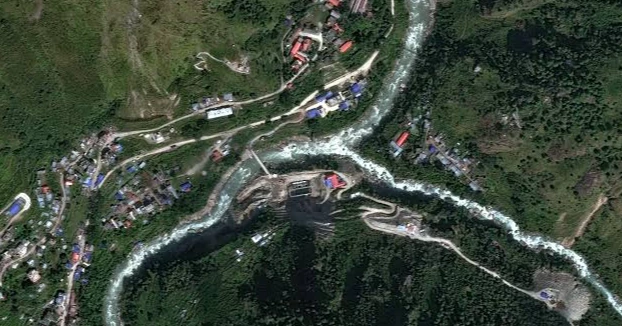
Satellite imagery has given scientists new clues about the cause of the devastating floods along the Nepal-China border, showing that a massive section of bedrock collapsed beneath a glacier before torrents of water and debris swept through valleys and communities.
The disaster on Wednesday killed hundreds of people in Nepal and Tibet, while hundreds more remain missing, including foreign nationals and religious pilgrims.
Earth scientists Kristen Cook and Dan Shugar initially struggled to examine the affected area because clouds and dust obscured satellite images from Nepal. They could only determine that part of a glacier had broken away from Langtang Lirung peak near the Tibetan border.
Clearer images taken Thursday showed that the bedrock beneath the glacier had also collapsed, carrying a huge mass of ice, rocks and boulders into the valley below.
Shugar, an associate professor at the University of Calgary, said the images indicated that the incident involved not only a glacier collapse but also a much larger failure of the mountainside's underlying bedrock.
The debris crashed into the valley and continued moving through the steep, narrow terrain. As the ice melted, it added more water to the flow, while mud and debris formed a massive torrent that swept through nearby settlements, said Cook of Université Grenoble Alpes in France.
Trishuli River expands after flooding
The Trishuli River rose sharply during the disaster. Satellite images taken before and after the floods show that the river has become considerably wider around Kolpurtar, Betrawati and Syapru Besi in Nepal.
The water has also changed from a greenish appearance to dark brown and black, indicating the enormous amount of sediment and mud carried by the floodwaters.
Several towns and villages along the river have been buried beneath mud and debris. In images of Betrawati, only parts of some houses remain visible above the destruction.
Syapru Besi, a popular tourist destination and the starting point for the Langtang trek, suffered extensive damage as buildings were swept away. A smaller river in the area also became wider after the powerful floodwaters forced water upstream.
Scientists assess possible climate connection
Alton Byers, a mountain geographer at the University of Colorado Boulder, described the affected area as a wasteland that could take years to recover.
Byers, who has lived in Nepal and continues to visit the country to study glacier-related hazards and help communities prepare for disasters, said the event was the largest glacier-related flood he had witnessed.
He believes climate change may have contributed to the disaster. Rising global temperatures are melting glaciers and permafrost, potentially weakening the rock, soil and ice that stabilize high mountain slopes.
According to Byers, the weakening of permafrost can make mountains increasingly unstable and trigger a chain of events involving rockfalls, glacier collapses and flooding.
However, Cook and Shugar cautioned that there is not yet enough evidence to establish a direct connection between this particular collapse and climate change.
Cook noted that landslides and slope failures naturally occur in mountainous regions, although the continued melting of permafrost is known to contribute to the destabilization of mountain slopes.
She said that while the current disaster could not yet be directly attributed to climate change, a warmer climate could make similar events more likely in the future.