
Satellite imagery and verified videos suggest that an Iranian primary school and a nearby military facility were struck multiple times during an attack in southern Iran that authorities say killed at least 168 people, many of them children.
Analysis of satellite images and footage indicates extensive damage around the Shajareh Tayebeh primary school in Minab and an adjacent compound belonging to the Islamic Revolutionary Guard Corps (IRGC).
Images show one building inside the IRGC base completely flattened, while the school building appears partially collapsed. Satellite analysis also identified several burn marks and impact craters across the area, suggesting multiple strikes occurred almost simultaneously.
Munitions expert N R Jenzen Jones said the concentration of impact sites close to each other indicates that the area may have been targeted with several strikes at once.
Verified videos recorded shortly after the incident show chaotic scenes as families and rescuers searched through the rubble for victims. Some people were seen holding up children’s schoolbags and books recovered from the debris.
Aerial footage filmed days later showed rows of freshly dug graves, reportedly for victims of the attack.
Iranian authorities blamed the United States and Israel for the strike, but neither country has accepted responsibility. Israel said it was not aware of any military operations in the area, while US Defense Secretary Pete Hegseth said Washington was investigating the incident and stressed that the United States does not target civilians.
The attack reportedly took place around 10:45am local time on Saturday, the first working day of the week in Iran.
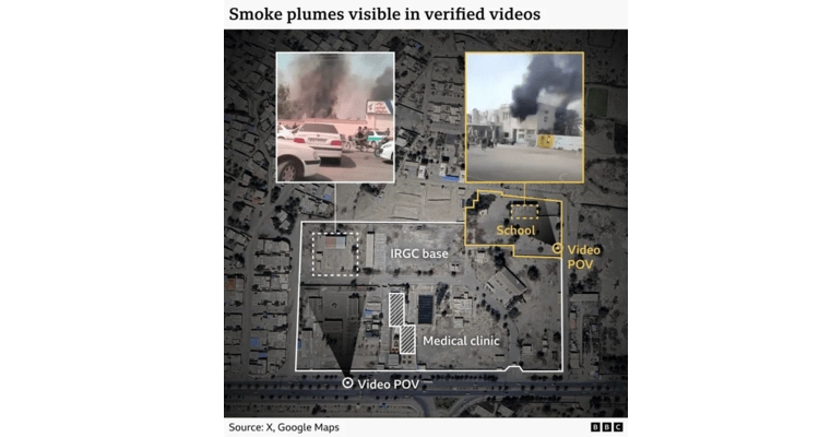
Footage verified from the scene shows smoke rising from both the school building and the nearby IRGC compound. Murals and Persian alphabet decorations on the school’s walls could be seen in the videos, confirming the location.
Other footage filmed from outside the nearby military base shows signs marking the entrance to facilities belonging to the IRGC, including the “Seyed al-Shohada educational and cultural corps” and a medical clinic linked to the IRGC navy.
Satellite images taken several days later revealed broader destruction than initially visible in the videos. Analysts identified at least five damaged buildings in the area along with visible craters and scorch marks.
Satellite imagery expert Jamon Van den Hoek of Oregon State University said the pattern of damage suggests one or more intended targets were located very close to each other, though the exact objective of the attack remains unclear.
Another analyst, Oz Smith of McKenzie Intelligence Services, said a crater visible inside the two-storey school building suggests a munition designed to penetrate deeper levels may have been used.
Earlier satellite images indicate the school and the IRGC base were once part of the same compound, although a wall separating them appeared in images taken several years later.
Questions also remain about who carried out the attack. Iran insists the United States and Israel were responsible, but both governments have denied involvement in the strike on the school.
Without physical evidence from the site, such as remnants of weapons used, analysts say it is difficult to determine who launched the attack.
Iranian officials say most of the 168 people killed were children. The education ministry said the school had 264 students enrolled.
A list published by Iranian media included the names of dozens of victims, many between the ages of six and 11, though these details could not be independently verified.
Photos from funerals broadcast by Iranian state media showed large crowds attending burial ceremonies, with several small coffins draped in the Iranian flag.
The US-based Human Rights Activists News Agency says more than 1,100 Iranian civilians have been killed since the conflict began, including at least 183 children.
With inputs from BBC