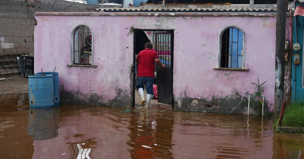
Hurricane Polo struck Mexico’s western coast on Tuesday, inundating coastal areas and knocking down trees before weakening and sending heavy rain toward the flood-hit U.S. Southwest, where residents of small New Mexico communities were evacuated over fears of a dam failure.
Polo made landfall in the Mexican state of Baja California Sur in the morning with maximum sustained winds of 110 mph (175 kph). It crossed the Gulf of California and weakened into a tropical storm as it moved inland toward the northeast. Its remnants were expected to reach the United States by Tuesday night.
North-central New Mexico, including Albuquerque and Santa Fe, could receive the heaviest rainfall, with 3 to 4 inches (8 to 10 centimeters) expected through Wednesday and potentially more, forecasters said.
The rain came after storms swept through parts of the U.S. Southwest overnight Monday, saturating the ground and increasing the risk of flooding.
Southwest US hit by heavy rain, flooding
Bands of rain continued moving across the Southwest, causing desert rivers to rise and normally dry arroyos to fill rapidly with floodwater.
Fears that a dam in south-central New Mexico could fail prompted evacuations in three small communities along the Rio Grande, affecting hundreds of residents. People in Rincon, Salem and Garfield were instructed to immediately move to higher ground “before conditions worsen.”
Nearly the entire region was under flood watches as a complex tropical weather system, with Polo at its center, moved northeast from Mexico.
“We’re definitely looking at the chances for urban flooding,” said Carter Greulich, a National Weather Service meteorologist in Albuquerque. “Don’t drive through flooded roadways. Remain out of the arroyos, especially in our urban areas.”
A person stranded on top of an overturned vehicle in floodwaters west of Phoenix was rescued Tuesday morning. Video released by Arizona Fire and Medical Services showed a helicopter lowering a rescuer to the person clinging to the vehicle.
A helicopter also rescued three people who had been in Heaps Canyon in Zion National Park after they moved to higher ground when flash flooding began.
North of Phoenix, a truck was swept away in a wash in the New River area, but the driver escaped safely, according to Maricopa County sheriff’s officials.
The rocky desert region typically receives less than 10 inches (25 centimeters) of rain a year and has little vegetation to absorb water, making it particularly vulnerable to flash floods.
Near Zion National Park in Utah, the East Fork of the Virgin River surged with muddy floodwater, with video showing a shipping container being carried downstream.
In Orderville, Utah, where flooding began Monday night, Sabrina Dubay said she was driving home when her partner called and warned her to stay away.
“The river came in and swept around the entirety of our house,” Dubay said.
A camper, snowmobile trailer and other belongings from Dubay’s yard were swept away by the river. Neighbors and friends arrived to dig a trench around the house as floodwater continued rising.
“It was coming in through our front doors,” she said.
Flooding was also reported in southern New Mexico. An unusually wet September had already left the ground saturated, meaning much of the additional rainfall was likely to run off rather than be absorbed.
“Runoff is likely going to start much quicker and lead to those flooding impacts quicker,” Greulich said.
Forecasters said the flood threat would spread into parts of the central United States from late Tuesday into Wednesday. Beginning late Wednesday, widespread heavy rain was expected in the Dallas-Fort Worth, Austin and San Antonio areas, with potentially life-threatening flash flooding, particularly in low-lying locations.
Parts of west Texas, Oklahoma, Kansas, Nebraska and Iowa were under flood watches through Thursday, with some areas expected to receive up to 5 inches (13 centimeters) of rain.
‘We were lucky’
Polo brought strong winds and heavy rain to Baja California Sur when it made landfall.
After the storm passed over the small fishing community of Puerto San Carlos on the Baja California peninsula, residents waded through ankle-deep water around fallen trees and flooded homes. The relatively limited damage brought relief to residents who had prepared for worse conditions.
Shopkeeper Elbia María Bachomo, 40, sorted through furniture scattered around her home. She and her three children had quickly gathered their clothes and left for a shelter Monday after water began entering the house.
Her husband was fishing for sardines when Polo struck. Bachomo said he was fortunate to survive.
“I thought, ‘Oh no, what are we going to come back to? We will be left with nothing.’ But we were lucky,” she said.
Polo was expected to bring 6 to 12 inches (15 to 30 centimeters) of rain to parts of Baja California Sur.
About 700 people remained in shelters Tuesday, but authorities expected them to return home. No serious damage or deaths had been reported immediately.
Meanwhile, the hurricane center said Tropical Storm Rachel was moving parallel to Mexico’s coast early Tuesday. It was located about 265 miles (425 kilometers) southwest of Lazaro Cardenas, with maximum sustained winds of 65 mph (105 kph), and was moving west-northwest at 13 mph (20 kph).
In the central Pacific, Hurricane Nolo remained a dangerous Category 3 storm Tuesday as it moved away from Hawaii after bringing heavy rain to parts of the Big Island over the weekend. The hurricane was approaching the Papahanaumokuakea Marine National Monument, a marine conservation area.
Pacific storm activity has been above average this year, a pattern consistent with El Niño years.