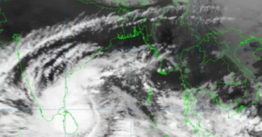
Mandous
Mandous turns into severe cyclonic storm, but won't hit Bangladesh: BMD
Cyclonic storm Mandous over the Southwest Bay of Bengal and adjoining area has moved west-northwestwards and intensified into a severe cyclonic storm over the same area.
"There is no possibility of the severe cyclonic storm lashing the Bangladesh coast, and it is likely to cross over India's Andhra Pradesh and Tamil Nadu coasts. It may weaken into a cyclone and then into a deep depression while making landfall," Meteorologist AKM Nazmul Haque of the Bangladesh Meteorology Department (BMD) told UNB.
Read: 1,000 more cyclone shelters to be set up: Enamul
The maritime ports of Chittagong, Cox's Bazar, Mongla and Payra have been advised to keep hoisting distant warning signal No. 2, meaning a storm – wind speed of 62-88km per hour – has formed in the distant deep sea; ships may fall into danger if they leave the harbour.
As of 6am today, the storm was centred about 1690km southwest of Chattogram port, 1640km southwest of Cox's Bazar port, 1560km southwest of Mongla port and 1565km southwest of Payra port.
"All fishing boats and trawlers over North Bay and deep sea have been advised to come close to the coast and proceed with caution. They were also advised not to venture into the deep sea," the BMD said.
Read: After playing down chances of Sitrang, Enamur now warns of December cyclone
"The sea will remain very rough in areas near the cyclone centre, with the sustained wind speed within a 64km radius rising up to 117kph in gusts."
3 years ago
Deep depression over Bay intensified into cyclonic storm ‘Mandous’
The deep depression over Southwest Bay and adjoining Southeast Bay moved west-northwestwards and intensified into cyclonic storm ‘Mandous’ over Southwest Bay and adjoining area.
The maritime ports of Chittagong, Cox’s Bazar, Mongla and Payra have been advised to keep hoisted distant warning signal no two, said a special weather bulletin.
The cyclonic storm was centred at 06 AM today about 1650 Km Southwest of Chattogram port, 1590- km Southwest of Cox’s Bazar port, 1565 km Southwest of Mongla port and 1550 km Southwest of Payra port. It is likely to move in a West-Northwesterly direction.
Read more: Severe Cyclonic storm ‘Asani’ to weaken into cyclonic storm
All fishing boats and trawlers over North Bay and deep sea have been advised to come close to the coast and proceed with caution. They were also advised not to venture in the deep sea.
Maximum sustained wind speed within 54 kms of the cyclone centre is about 62 kph rising to 88kph in gusts or squalls. Sea will remain very rough near the eye of the cyclone.
However, according to latest bulletin of Bangladesh Meteorological Department (BMD) the wind speed at Dhaka is 8-12 kph directed North/North-easterly and the weather may remain mainly dry with partly cloudy sky over the country.
Read more: Deep depression in Bay intensifies into cyclonic storm ‘Asani’
3 years ago


